Vetting the Water Before You Price the House: The Specialized Technical Due Diligence That Most Realtors Overlook
Navigating the Differences: Which Neighborhood Wins for Your Vessel? When analyzing premium North Miami waterfront residential enclaves, evaluating properties from an onboard operational perspective is critical. Choosing between Sans Souci and Keystone Islands dictates your maximum vessel parameters and weekly navigation constraints.
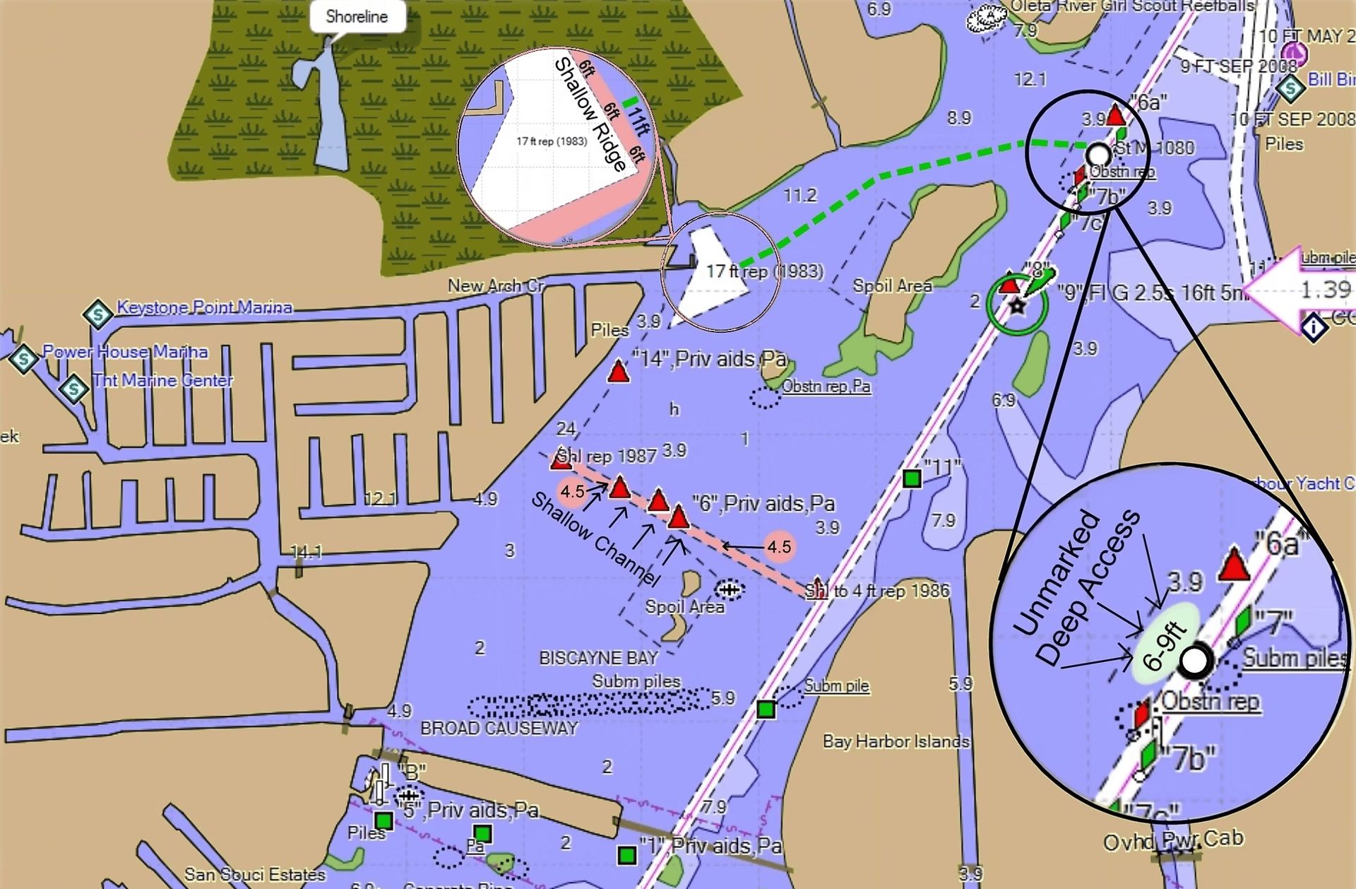
- Navigational Differences: Sans Souci offers direct access to Biscayne Bay with no fixed bridges, whereas Keystone Islands can be more complex, featuring interconnected canals and two small fixed bridges (8–10 foot clearance) that require most vessels to exit via the New Arch Creek channel.
- Water Depth and Protection: Keystone Islands generally offers deeper waterways, with depths ranging from 10–20 feet and canal widths of 75–100 feet. In contrast, Sans Souci canals are typically shallower (5–10 feet) and less protected from wind and swells.
- Marine Services: Keystone Islands is a larger and more boating-oriented neighborhood, offering on-site marinas with fuel, haulout services, and dry storage. Sans Souci is strictly residential and lacks these immediate maritime amenities, requiring residents to travel to places like the Haulover Marine Center for fuel and service.
Quick Orientation
Both Sans Souci and Keystone Islands sit in North Miami, with man-made canals that connect directly to Biscayne Bay and the Intracoastal Waterway. Your experience on the water depends on the exact home’s canal location, the existing dock infrastructure, the route to the bay, and any bridges or channels in between. In this guide, you will learn how to assess the pros and cons of each neighborhood from a mariner's perspective.
Key Boating Factors to Compare
Canal Layout and Route Efficiency
Study the canal map for each property. Count the turns, calculate the distance to reach open water, and note any dead-ends that may suffer from shallower water or poor circulation. A straighter route translates directly to less time spent navigating at mandatory idle speeds and fewer tight maneuvers for large hulls.
This represents a primary structural variance between the two communities. In Sans Souci, all canals dump directly into Biscayne Bay, though they are less protected from crosswinds, tidal swell, and chop. Conversely, in Keystone, approximately half of the residential fingers are interconnected and require navigating through New Arch Creek to access open water.
- Track your precise transit path to reach Biscayne Bay or the ICW corridor.
- Identify all state-mandated manatee no-wake speed zones along your route.
- If regular family outings are planned, test the channel route constraints across different tidal phases.
Depth and Tides
Canal and waterway depths fluctuate dramatically and may register significantly shallower or deeper than the open bay. Diurnal tides directly affect how much draft you can safely manage at your slip and along the interior canal beds. With consistent depths of 10–20 feet, Keystone delivers robust deep-water capabilities across canals measuring 75–100 feet wide. The canals in Sans Souci also offer sufficient water depths (5 to 10 feet) for standard sportfishers, but lack the extreme vertical margins found across the Keystone network.
Captain’s Field Intel: Always measure depth at the dock using a low-tide benchmark. If you run a high-capacity hydraulic boat lift, verify vertical overhead clearance thresholds at both high and low water lines to prevent hull or structural contact.
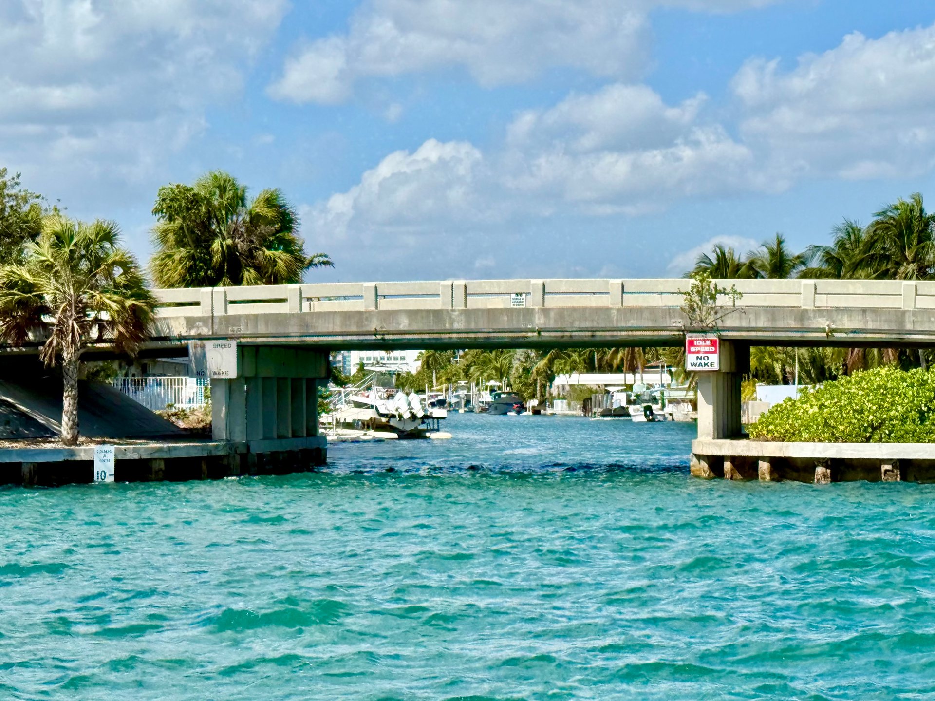
Bridges and Clearances
Man-made island developments inherently involve fixed or opening bridges, meaning your vessel's air draft is just as critical as its underwater draft. While Sans Souci features zero fixed bridges to the bay, vessels carrying a vertical clearance greater than 16–18 feet must request timed openings at the Broad Causeway bascule bridge. By comparison, Keystone contains two fixed internal bridges carrying restrictive clearances of roughly 8–10 feet. Depending on your lot position in Keystone, you may be legally forced to exit via the northern New Arch Creek channel, which increases idle run times.
- Map every bridge structure on your route, classifying them as fixed or opening bascule spans.
- Verify vertical clearance against Mean High Water (MHW) metrics, not low tide charts.
- If utilizing the Broad Causeway opening, account for seasonal vehicular traffic delays and restricted bridge operating schedules. See the Florida ICW bridges resource for schedule details.
Haulover Inlet Access
Haulover Inlet is the primary ocean gateway north of central Miami, handling heavy recreational, sportfishing, and commercial traffic. The inlet is notoriously dynamic, shaped by powerful velocity currents, wind-on-tide conditions, and heavy weekend convergence.
- Time your real-world transit from the dock to the inlet sea buoy under typical operating conditions.
- Expect major structural variability in chop based on wind directions and outgoing tidal flow.
- If offshore fishing or blue-water crossings are your family's priority, execute a trial run prior to closing a transaction.
Marinas, Fuel Infrastructure, and Repair Access
This highlights a major dividing line between the two enclaves. While Sans Souci is exclusively residential with zero on-site commercial services, Keystone offers close proximity to private marina configurations featuring dry storage, commercial wet slips, haul-out facilities, and pump-out stations. Marine fuel is conveniently accessible to both via a short run to the Haulover Marine Center Fuel Dock position on your way out to the ocean.
Sans Souci vs. Keystone Islands: How to Decide
Because canal depths, bridge lines, and navigation routes shift on an address-by-address basis, the smart decision relies entirely on explicit lot data rather than general neighborhood branding. Execute this due diligence protocol:
- Use marine chartplotters to track the precise route from your prospective slip out to open water.
- Log exact low-tide water depths at both the bulkhead line and the center canal exit.
- Calculate air draft clearances at high tide against all bridge structures.
- Time the idle transit speed run during peak weekend waterway traffic conditions.
- Audit the structural history by reviewing dock, lift, and seawall permits alongside county dredging logs.
- Verify community bylaws regarding waterward structures via the Miami-Dade Code of Ordinances to isolate lift extensions or trailer rules.
If two properties deliver equal utility on land, the estate backed by a cleaner navigation artery and superior marine engineering data will always preserve more long-term value for boating families.
The Captain’s Advantage: Technical Infrastructure Analytics
Aesthetic designs attract attention, but canal depth profiles, bridge air-drafts, and riparian boundaries dictate absolute property liquidity. Standard residential agents analyze square footage—mariners calculate navigational access.
Leveraging over 25 years of local maritime command and luxury transaction execution, I provide the precise site intelligence required to vet a marine asset or list a premier estate. Do not expose your capital to risk—ensure your dockage rights are audited by a licensed Master Mariner.