Shopping for a Keystone Islands home with your own dock? If you run your own boat, the phrase “no fixed bridges” can make or break the deal. It sounds simple, yet the details behind it determine what size vessel you can run, how fast you reach Biscayne Bay, and whether you can safely reach the Atlantic through Haulover Inlet. In this guide, you’ll learn what “no fixed bridges” really means in North Miami, how to verify a clear route, and the practical checks that protect your boating plans. Let’s dive in.
What “no fixed bridges” means here
In real estate, “no fixed bridges” usually means there are no low, non‑opening bridges that permanently limit your boat’s air draft between leaving your dock and the open water. In Keystone Islands, that often refers to direct access to Biscayne Bay and onward to Haulover Inlet and the "outside".
MLS phrasing can vary. You might see “no fixed bridges to bay” or “no fixed bridges to ocean,” which are not the same premise. Always verify the actual route from the address. Use official sources like the charts in Garmin's Active Captain and the NOAA Nautical Charts to confirm the distances, bridges and route between your dock and the bay or inlet.
Keystone Islands routes to open water
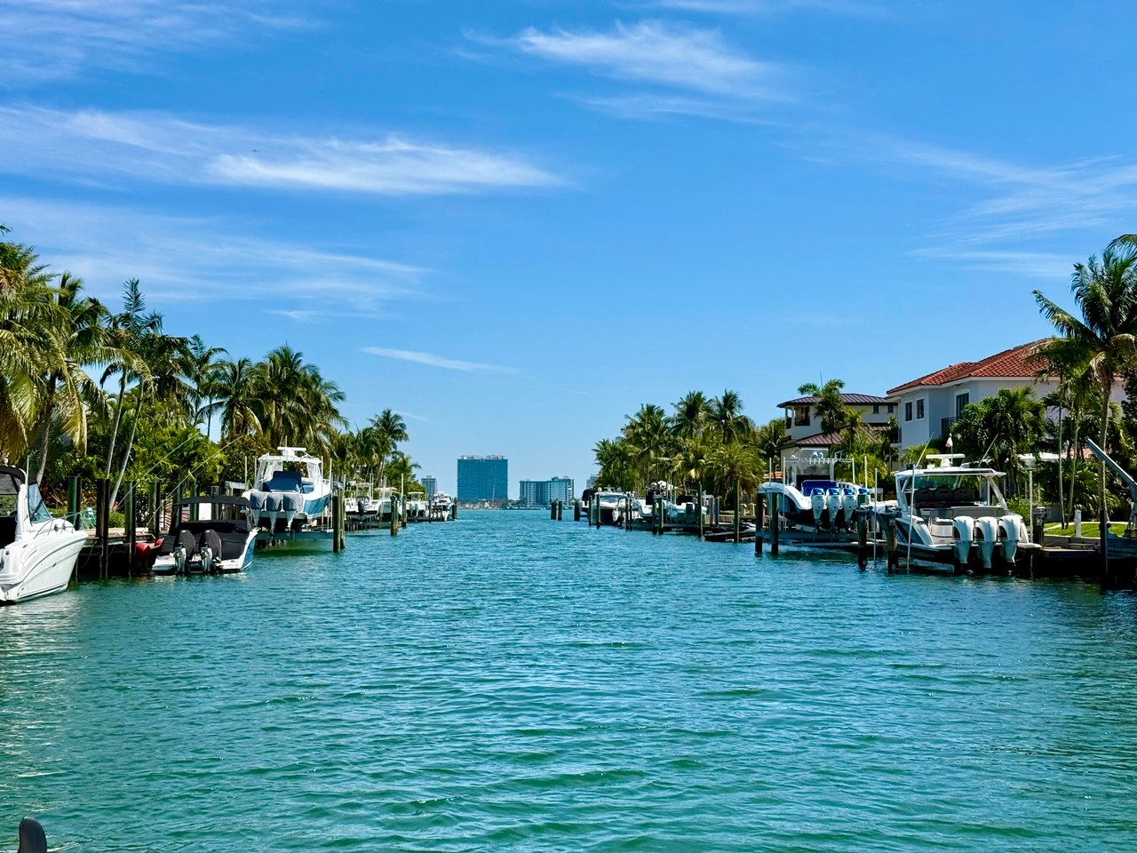
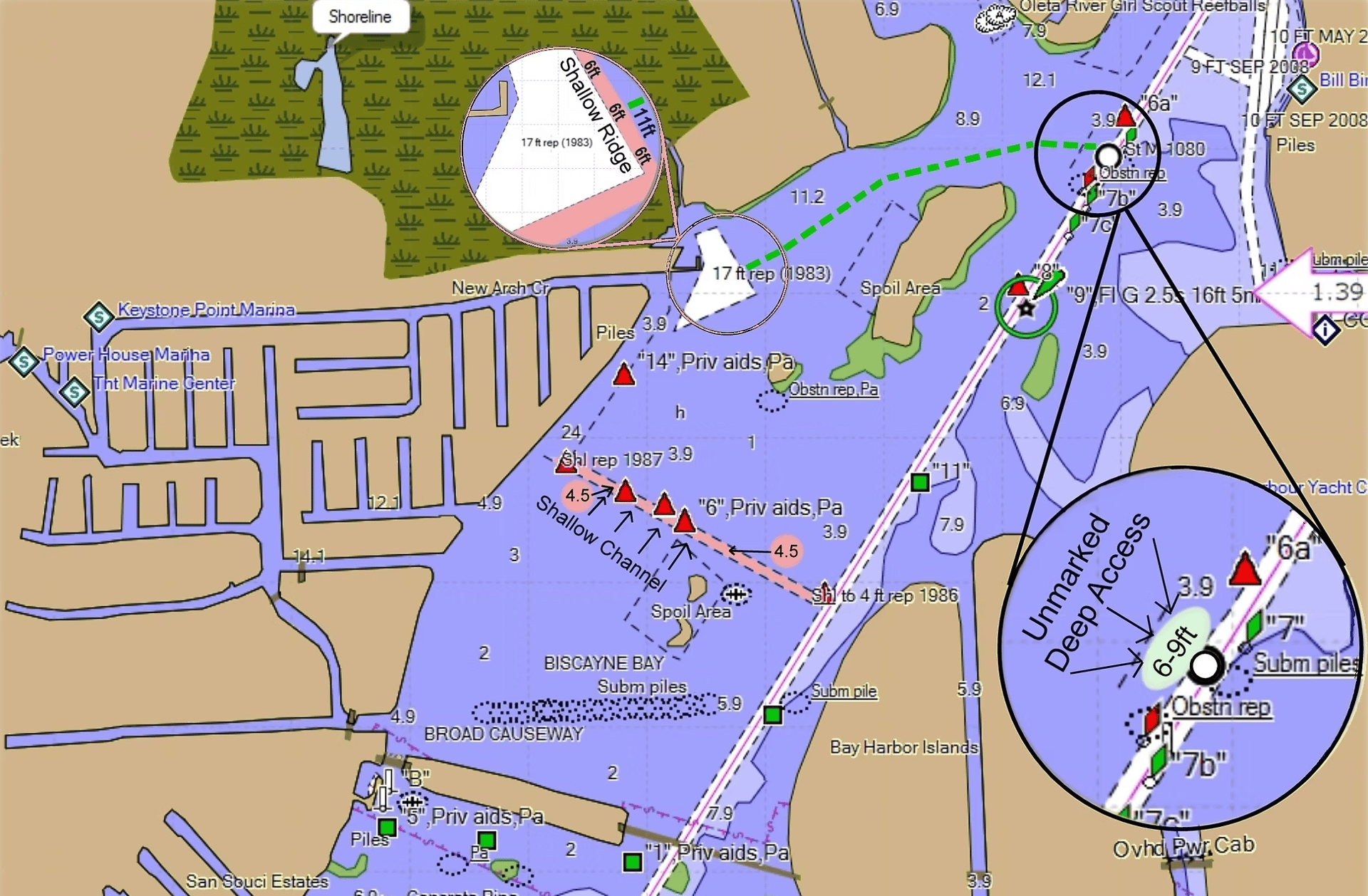
From most of the Keystone Islands, owners run through channel network toward the north channel or New Arch Creek, then proceed north around Sandspur Island and east towards Haulover Inlet to reach the Atlantic. Depending on your location within the community, you can expect this to take up to 50 minutes at idle speed. The distance to the Haulover inlet is approximately 2-4 miles depending on your specific location within the islands.
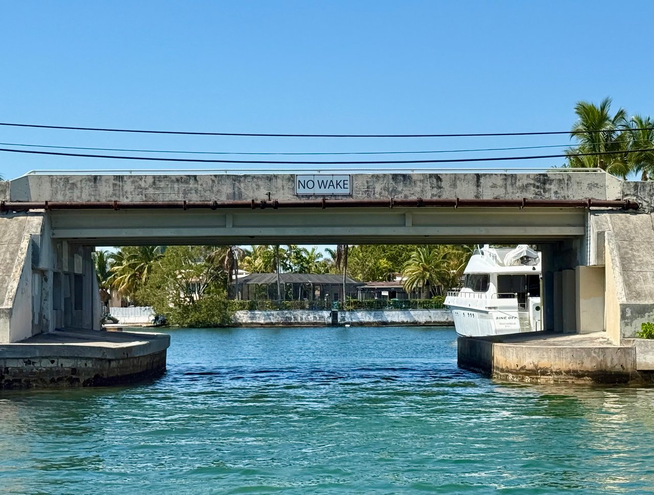
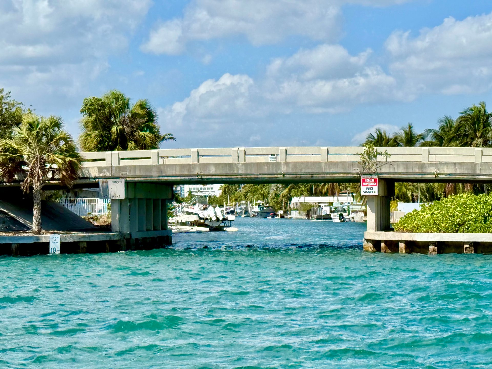
There are two fixed bridges within Keystone between the 123rd Street entrance and Island No 1, as well as between Keystone Islands No 1 and 2. Depending on the tides and swell, the air draft is typically 8-10 feet, hence the vast majority of boat owners run their boats through the island network to exit in the north channel.
What sets Keystone apart from many boating communities is that its channel network is all deep water (15-20 ft depth) and the approach around Sandspur Island is 12-20 ft depth. This allows for larger yachts up to 80 or 100 feet to access the Keystone Islands.
Haulover Inlet is your primary ocean pass for the majority of Miami's waterfront communities north of the Julia Tuttle Causeway through Sunny Isles Beach. The air draft under the Haulover bridge is approximately 30-32 feet.
Haulover Inlet essentials
Haulover is maintained by the U.S. Army Corps of Engineers and can shoal after storms. For depth and maintenance updates, review the U.S. Army Corps of Engineers notices for Haulover Inlet. Before each trip, consult NOAA Tides & Currents for predicted highs and lows and look at recent observations.
This inlet is infamous for fast moving water, large swell, heavy boat traffic and chop. When conditions pick up, even charted depths can feel tight for deep or tall vessels. Be especially cautious if you are exiting in a smallish vessel, especially with a strong outgoing tidal flow, spirited onshore winds, and during busy weekend hours. If you are new to the inlet, talk with nearby marina managers or a local captain for real‑time insight on timing and routes.
Air draft: clearances and datum
“Air draft” is the height of your boat above the water. Bridge clearances are published on NOAA charts and in bridge inventories, but those numbers are tied to a tidal datum. Some clearances are shown above Mean High Water, others above Mean Low Water. That difference matters.
- Measure your boat’s true air draft when loaded for normal use. Include the highest fixed point like mast, radar, and arches.
- Note anything that can be temporarily lowered or stowed and record both measurements.
- Compare your air draft to published bridge clearances and use a conservative safety margin for tide swings and measurement tolerance.
If you see “no fixed bridges,” still trace the exact route and confirm every structure’s clearance against your boat’s air draft. When in doubt, look up official data on the NOAA Chart Viewer and confirm local inventories.
Depth: draft and under‑keel margin
Depth is the other half of the equation. Published channel depths are targets that can change with dredging, storms, and seasons. Your boat’s draft plus an under‑keel safety margin must fit the controlling depth along your whole route, including your slip.
- Check the controlling depth for the channels you will use and add margin for tides, squat, waves, and loading.
- Confirm recent surveys and dredge status for Haulover and nearby channels through the U.S. Army Corps.
- Ask neighbors and marina managers about seasonal shoaling and any private canal maintenance patterns.
Haulover and nearby channels can shift after storms. Always re‑check before moving a deep‑draft vessel, especially after heavy weather.
Boat types that benefit most
- Trawlers and motor yachts. Superstructures vary. No fixed bridges reduce planning complexity and delays.
- Sportfish and larger center consoles. Bridge height is less of a concern, but channel depth, beam, and turning room at the dock still matter.
Even with no fixed bridges, canal width, turning basins, dock infrastructure, and local rules can limit what is practical. Confirm beam, length, and service access before you buy.
Due‑diligence checklist for buyers
Use this step‑by‑step process when a listing claims “no fixed bridges.”
-
Verify the claim. Ask the listing agent for the exact language and any supporting material like a marked route on a chart. Cross‑check with NOAA Nautical Charts and the NOAA Chart Viewer.
-
Confirm vertical clearances and datum. Gather published clearances for every structure on your route. If necessary, confirm whether numbers are referenced to Mean High Water or another datum. Compare to your measured air draft with a safety margin.
-
Confirm depth and shoaling risk. Obtain current channel depths and recent survey data. Review U.S. Army Corps of Engineers Haulover Inlet updates and ask local marinas or neighbors about seasonal shoaling.
-
Check operational constraints. Note idle speed and no‑wake zones. Review any HOA or municipal rules on vessel length, beam, or liveaboard policies. Confirm haulout and service yard options that match your vessel’s size.
-
Monitor safety notices and tides. Subscribe to the U.S. Coast Guard Local Notice to Mariners. Use NOAA Tides & Currents to plan around highs, lows, and predicted extremes.
-
Engage professionals. Hire a marine surveyor to inspect the dock and measure slip depth. Speak with Captain Ross or local marina manager about recent transits from the neighborhood.
Long‑term planning: riparian rights, maintenance and storms
Properties with clear, documented sea access and adequate depth are often more attractive to active boaters and may command a premium. Before you buy, learn who maintains the access canals and what happens when they silt in. Learn about Florida's riparian rights that govern access to and use of adjacent waterways. Responsibilities can sit with the U.S. Army Corps of Engineers, state, city, county, an association, or private owners.
Plan for hurricane season. Unrestricted access helps you move a vessel early, but inlet conditions, bridge openings elsewhere, and yard capacity all matter. Build relationships with marinas, haulout yards, and service teams that can handle your boat on short notice.
How a Specialist Adds Value: The "Dock-to-Doorstep™" Approach
A waterfront purchase in Keystone Islands blends lifestyle with technical judgment. You need confidence in seawall integrity, canal depths, and your specific riparian rights. As a USCG-Licensed Captain, I help you see the property from the water side—verifying vessel clearance and route planning before you commit.
New Regulatory Alert: Current laws require a signed representation agreement before you begin touring estates. Don't lock yourself into a contract with a generalist; ensure your maritime interests are protected by a specialist from Day One.
FAQs
What does “no fixed bridges” mean in Keystone Islands?
- It means your route from the property’s dock to Biscayne Bay and onward to Haulover Inlet does not include low, non‑opening bridges that restrict your boat’s air draft, but you should still verify clearances and depths for your exact route on official NOAA charts.
How should I check Haulover Inlet conditions before a run?
- Review U.S. Army Corps updates for Haulover, look at tide predictions on NOAA Tides & Currents, and scan the U.S. Coast Guard Local Notice to Mariners for temporary hazards.
Can my sailboat reach the ocean from the Keystone Islands?
- Not guaranteed by the phrase alone; measure your mast height, confirm published bridge clearances and datum along the route, and verify channel depths against your draft with a conservative safety margin.
Who maintains the canals if they shoal near my dock?
- Responsibility varies by location and can involve the U.S. Army Corps of Engineers, state, county, city, or private owners, so confirm maintenance history and any assessments during due diligence.
What if my canal depth looks shallow at low tide?
- Get on‑site measurements and recent depth data, factor in your vessel’s draft plus safety margin, and consult local marinas and surveyors about seasonal shoaling and maintenance patterns.